The tornado count in Wisconsin on April 10, 2011 now stands at 15. Originally, it was 14. The additional tornado occurred in far northeastern Green Lake County.In the past couple weeks, we re-examed severe weather spotter reports, a public damage report, and our WSR-88D Doppler radar imagery. In fact, one spotter-chaser actually saw the tornado suck dirt out of a farm field. Minor damage was noted to a few tree branches, some lawn furniture, and a wooden structure on Meadowbrook Rd.Preliminary data follows...EF0 - wind about 80 mph827-829 pm3.5 SSE Berlin to 3.4 SE Berlin (northeast movement)Path length about 2 milesMaximum width about 50 yardsNo fatalitiesNo injuries
May 11, 2011 is NOAA Weather Radio All Hazards Awareness Day in Wisconsin. The campaign is to encourage Wisconsin residents to keep ahead of severe weather by listening to NOAA Weather Radio All Hazards, a 24-hour source of weather forecasts, watches, warnings, and non-weather emergency information provided by the National Weather Service and its parent agency, the National Oceanic and Atmospheric Administration (NOAA).
Weather radios are known as “smoke detectors for severe weather and hazardous conditions.” A NOAA Weather Radio with an alarm and battery back-up is one of the best ways to protect your family, especially at night when the alarm feature can wake you up during severe weather and give you and your family time to seek appropriate shelter. If there is no severe weather then your weather radio can be switched to a silent, stand-by mode.The NOAA Weather Radio All Hazards network started in 1972 and is the sole government-operated radio system to provide direct warnings for all hazardous conditions that pose a threat to lives and property. There are over 35 stations that broadcast weather and hazards information to the residents of Wisconsin, and over 1000 stations nationwide. Weather radios come in many sizes with a variety of functions. They can be purchased at most electronic stores and some office supply and hardware stores. Most weather radio receivers are either battery-operated portables or AC-powered desktop models with battery backup. The portable weather radios are an important item to take along when you are outdoors, especially when at a ball game, camping or boating. Many receivers have digital technology called Specific Area Message Encoding (SAME) that allows users to program their radios to alarm only for hazardous conditions that affect their county. A weather radio is an essential part of a severe weather safety plan. Every home, business, and public area should have a NOAA Weather Radio. For more information on NOAA Weather Radio-All Hazards, please visit the NWS Milwaukee/Sullivan Weather Radio web site at: http://weather.gov/mkx/nwr source: http://www.crh.noaa.gov/news/display_cmsstory.php?wfo=mkx&storyid=68097&source=0 Although the major metro areas like Madison, Milwaukee, and Chicago were spared, at least 14 tornadoes, including four strong tornadoes (EF2 or EF3), were documented in portions of mainly rural central and northern Wisconsin. The potential for a tornado outbreak in the Wisconsin area was advertised almost a week out with the models showing favorable conditions ripe for the tornado outbreak.
April 10 2011 will go down as the biggest daily April tornado outbreak (in terms of total tornadoes) in Wisconsin history. The other big April tornado outbreak was on April 27 1984, when 10 tornadoes occurred, of which 6 were considered at least strong. This included the violent Wales Tornado in Waukesha County, rated an F4, and another F4 tornado in Winnebago and Outagamie Counties. The EF3 tornado on April 10, 2011 occurred near Merrill in Lincoln County. EF2 tornadoes were also documented in Adams County, Forest County, and Brown County (see table and graphic below for locations). These are the first strong tornadoes in 17 years for the month of April in Wisconsin (the last being April 26 1994 in NW Wisconsin). They are also the first strong tornadoes in 27 years in the month of April for central or southern WI (April 27 1984). Damage assessment continues, which means more tornadoes may be found and recorded in the next few days. Below is a rough plot of the tornado locations and EF-rating. Below is a listing of the April 10th tornadoes in Wisconsin...subject to change as new information becomes available. TORNADOES ARE THE MOST ERRATIC...MOST UNPREDICTABLE...AND MOST VIOLENT OF STORMS ON EARTH. THEY MOST COMMONLY OCCUR IN WISCONSIN DURING THE WARMER PART OF THE YEAR...WITH THE MONTHS OF MAY...JUNE... AND JULY BEING THE PEAK MONTHS. A TORNADO MAY RANGE FROM A FEW YARDS TO NEARLY A MILE IN WIDTH. IT MAY PROPAGATE VERY SLOWLY OR AS FAST AS 60 MILES AN HOUR. IT MAY SKIP ALONG OR EVEN MAKE A U-TURN. IT MAY TRAVEL ALONG THE GROUND A FEW HUNDRED FEET OR SEVERAL HUNDRED MILES. THEY MAY APPEAR SINGLY OR IN GROUPS.
FOR YOUR OWN PROTECTION...BE FAMILIAR WITH TORNADO SAFETY RULES AND HAVE A PRE-ARRANGED PLAN TO GET TO SAFE SHELTER WHEN THESE DEADLY STORMS THREATEN. THE NATIONAL WEATHER SERVICE WILL ISSUE AND BROADCAST TORNADO WATCHES AND WARNINGS. MAKE SURE YOU HAVE A NOAA WEATHER RADIO AVAILABLE...PREFERABLY ONE THAT CAN OPERATE ON BATTERIES. LISTEN FOR DIRECT TORNADO WATCH OR WARNING INFORMATION ON NOAA WEATHER RADIO...OR LISTEN TO OTHER COMMERCIAL RADIO OR TV STATION BROADCASTS. BE SURE YOU UNDERSTAND THE DIFFERENCE BETWEEN A TORNADO WATCH AND TORNADO WARNING. THE NATIONAL WEATHER SERVICE ISSUES A TORNADO WATCH TO GIVE YOU ADVANCE NOTICE THAT TORNADOES ARE POSSIBLE IN YOUR LOCALITY. THIS GIVES YOU THE TIME TO MAKE PRELIMINARY PLANS FOR MOVING TO A SAFE SHELTER QUICKLY IF A TORNADO WARNING IS ISSUED. THE TORNADO WARNING IS AN URGENT ANNOUNCEMENT THAT A TORNADO HAS BEEN REPORTED OR DETECTED BY RADAR AND WARNS YOU TO TAKE IMMEDIATE PRECAUTIONS. WHEN A WARNING IS ISSUED...MOVE QUICKLY...SECONDS SAVE LIVES. IF YOU ARE CAUGHT IN THE OPEN DURING A TORNADO WARNING...TRY TO HIDE IN A DITCH OR RAVINE. LIE FLAT AND COVER YOUR HEAD. IF YOU CAN... WRAP A COVERING AROUND EXPOSED PORTIONS OF YOUR BODY. EVEN SMALL GROUND DEBRIS CAN CAUSE SERIOUS INJURY WHEN DRIVEN BY TORNADO STRENGTH WINDS. THE NATIONAL WEATHER SERVICE ADVISES YOU TO MEMORIZE THESE BASIC SAFETY RULES...YOUR LIFE MAY DEPEND ON KNOWING THEM. IF YOU LIVE IN A MOBILE HOME...BE SURE YOU HAVE A PLAN OF SAFE ACTION SHOULD THE WEATHER BECOME THREATENING. THE SIZE AND CONSTRUCTION OF MOBILE HOMES MAKE THEM PARTICULARLY VULNERABLE TO OVERTURNING AND ROLLING IN HIGH WINDS. SOME PROTECTION MAY BE PROVIDED AGAINST THIS HAZARD BY SECURING THEM WITH CABLES ANCHORED IN CONCRETE FOOTINGS. BUT...FOR SAFETY SAKE...WHEN HIGH WINDS ARE IMMINENT...MOBILE HOMES SHOULD BE EVACUATED FOR SUBSTANTIAL SHELTER. IF SUBSTANTIAL SHELTER IS NOT AVAILABLE...LIE FLAT IN A DITCH OR RAVINE AND COVER YOUR HEAD. HOWEVER...WATCH FOR POSSIBLE FLOODING. IN THE HOME...THE SAFEST PLACE FROM TORNADO WINDS IS IN A BASEMENT OR CELLAR BELOW GROUND LEVEL. IF POSSIBLE...GET UNDER A STURDY TABLE OR WORK BENCH. IF A BASEMENT OR CELLAR IS NOT AVAILABLE...TAKE COVER IN AN INTERIOR CLOSET...HALLWAY...OR BATHROOM ON THE LOWEST FLOOR OF THE HOUSE. SOME PEOPLE HAVE FOUND THAT AN EMPTY BATH TUB WITH A MATTRESS OR BLANKET FOR A COVER MAKES A GOOD EMERGENCY REFUGE. DON/T OPEN WINDOWS OR DOORS...THIS ACTION WILL WASTE PRECIOUS SECONDS THAT COULD BE USED TO SEEK THE PROPER SHELTER. OPENING YOUR WINDOWS...DOORS...OR THE GARAGE DOOR WILL ALLOW WINDS TO PENETRATE YOUR HOME...LEADING TO A PRESSURIZATION OF YOUR HOME. THIS PRESSURIZATION MAY LEAD TO THE SO-CALLED EXPLOSION THAT PEOPLE REPORT. ALSO...KEEP IN MIND THAT BROKEN GLASS AND OTHER FLYING DEBRIS BECOME MISSILES THAT CAN INJURE OR KILL A PERSON.Source: http://www.crh.noaa.gov/product.php?site=mkx&product=pns&issuedby=MKX&format=CI&version=1&glossary=0 An active weather pattern is shaping up for tonight through Sunday night. The severe weather potential will come in 2 rounds. The first round, tonight into Sunday morning, will be due to a strengthening low level jet stream that will combine with an approaching warm front to generate a round of strong to severe thunderstorms.
The primary severe weather threat tonight will be large hail. By Sunday afternoon, the warm front will have lifted well north of the area, allowing a warm and humid airmass to settle over southern Wisconsin. Clearing skies behind the early morning thunderstorms should allow temperatures to climb into the lower 80s by Sunday afternoon. Dew points will also reach the lower to mid 60s. The last time the temperatures reached 80 or higher was back on October 10, 2010 at Milwaukee, and October 11, 2010 at Madison. As low pressure strengthens and moves across east central Minnesota and northern Wisconsin Sunday afternoon and evening, it will drag a cold front across the region, interacting with the unstable airmass and generating another round of thunderstorms. These storms will likely reach severe levels, with a threat of large hail, widespread damaging winds and strong tornadoes. Please check back for further updates on this potential widespread severe weather outbreak for Sunday afternoon and evening. Source: http://www.crh.noaa.gov/news/display_cmsstory.php?wfo=mkx&storyid=66253&source=0 There is a high chance for severe weather today in southern Wisconsin and parts of central Wisconsin.
For More Information: http://www.crh.noaa.gov/news/display_cmsstory.php?wfo=mkx&storyid=66115&source=0 http://www.spc.noaa.gov/ Information on the pacific area: http://ptwc.weather.gov/?region=0
Information from the west coast/Alaska area: http://wcatwc.arh.noaa.gov/ Information on the 8.9 magnitude Honshu Japan Earthquake: http://earthquake.usgs.gov/earthquakes/eqinthenews/2011/usc0001xgp/#details 2/21/2011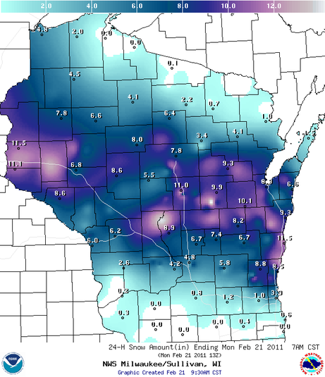 Source: http://www.crh.noaa.gov/mkx/hydanalysis.php?loc=wi&element=SnowFall&yearmonthday=20110221&submit=Submit 2/22/2011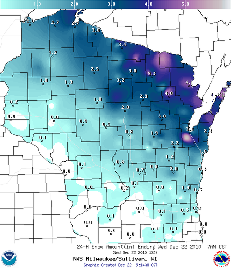 Source: http://www.crh.noaa.gov/mkx/hydanalysis.php?loc=wi&element=SnowFall&yearmonthday=20110222&submit=Submit Source: http://www.crh.noaa.gov/news/display_cmsstory.php?wfo=mkx&storyid=63902&source=0 Due to the recent cold temperatueres, the Ice on the West Shore of Lake Michigan has thickened as seen on the Feb 9th MODIS polar orbiter image. 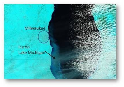 The image below was produced on Feb 10th. Notice the expansion and thickening of the ice cover. 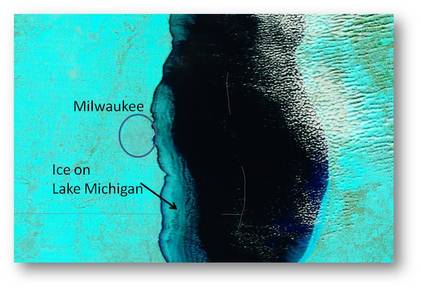 Wisconsinsevereweather.weebly.com is not part of the national weather service.
Cold weather will be moving through the state today and tomorrow with wind chill down around -20 or lower in some spots.
| Wisconsin Severe WeatherWisconsin severe weather is a webpage where you can find weather info for Wisconsin. ArchivesDecember 2012 CategoriesAll  |
 RSS Feed